

Definitions; 1ºH
The Earth’s crust is made up of big pieces called tectonic plates. These plates are always moving slowly. When two plates push against each other, they can make the land rise and form mountains. That’s how mountain ranges are made—when tectonic plates crash or move toward each other
A volcano is a mountain that opens downward to a pool of melted rock (magma) under the Earth’s surface. When pressure builds up, it erupts.
Crater: The bowl-shaped opening at the top of a volcano where lava, ash, and gases come out during an eruption.
Vein: A thin layer or channel of minerals or magma that moves through cracks in rocks beneath the Earth’s surface.
Cone: The mountain-shaped structure formed by layers of lava, ash, and rocks after repeated volcanic eruptions.
Magma: Hot, melted rock found beneath the Earth’s surface that can erupt as lava from a volcano.
1. Horst:
A horst is a raised block of land between two faults. It is pushed up when the land around it moves down.
2. Graben:
A graben is a block of land that has dropped down between two faults. It happens when the crust stretches and breaks.
Mountain ranges are formed when tectonic plates—the large pieces of the Earth’s crust—move and collide with each other.
When two plates push against each other, the land between them gets squeezed and pushed upward, creating mountains over a very long time. This process is called orogeny.
🏔️ Example:
The Himalayas were formed when the Indian plate crashed into the Eurasian plate. That’s why Mount Everest is there today!
So in simple words:
Mountain ranges are made when Earth’s plates crash together and push the ground up
A continental shelf is a portion of a continent that is submerged under an area of relatively shallow water, known as a shelf sea. Plataforma continental: Es una porción de un continente que está sumergida bajo un área de agua relativamente poco profunda, conocida como mar epicontinental.
Continental slope: The slope between the outer edge of the continental shelf and the deep ocean floor.Talud continental: Es la pendiente entre el borde exterior de la plataforma continental y el fondo oceánico profundo.
Ocean basin: depression of the earth’s surface in which an ocean lies.Cuenca oceánica: Depresión en la superficie terrestre en la que se encuentra un océano.
Mid Ocean Ridge: a long, seismically active submarine ridge system situated in the middle of an ocean basin and marking the site of the upwelling of magma associated with sea-floor spreading. An example is the Mid-Atlantic Ridge. Dorsal mediooceánica: Es un sistema de dorsales submarinas sísmicamente activas, situado en el centro de una cuenca oceánica y que marca el sitio de ascenso del magma asociado con la expansión del fondo marino. Un ejemplo es la Dorsal Mesoatlántica.
Rift: break in the Earth’s crust created by it spreading or splitting apart. Rift: Fisura en la corteza terrestre creada por su separación o división.
Sea trench: An ocean trench is a deep indent in the surface floor of the ocean and is the deepest part of the ocean. Fosa oceánica: Una fosa oceánica es una profunda depresión en el fondo del océano y representa la parte más profunda del océano.
Map Projections
When we make a map of the Earth (which is round) on a flat piece of paper, we have to “project” it. A map projection is a way of showing the curved Earth on a flat map. There are different ways to do this, and each one changes the shape or size of places a little.
Here are the three main types:
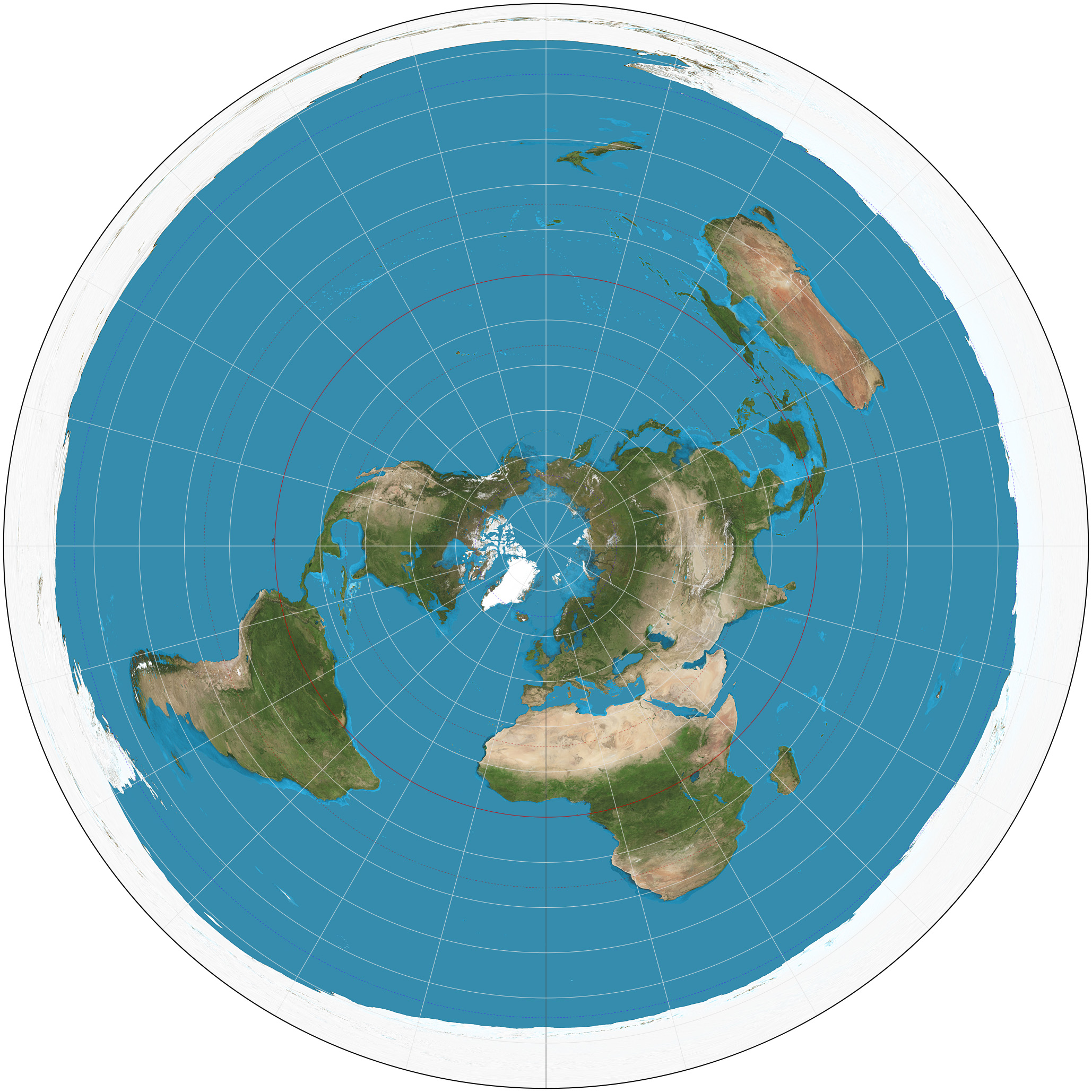
1. Azimuthal Projection
- Imagine putting a flat piece of paper on top of a globe.
- It shows the Earth from above—like looking down at the North or South Pole.
- Good for showing polar areas.
- Shapes and distances get more distorted the farther you move from the center.
🧊 Example: A map of Antarctica or the Arctic.

📦 2. Cylindrical Projection
- Imagine wrapping a piece of paper around a globe like a cylinder.
- Then, project the Earth’s surface onto that cylinder.
- The most famous one is the Mercator projection.
- It keeps shapes mostly right, but makes places near the poles look way bigger than they really are.
🌍 Example: Greenland looks HUGE on this map, even bigger than Africa—but it’s not!

3. Conical Projection
- Imagine placing a cone over the Earth and projecting the land onto it.
- Best for showing smaller areas, like countries or continents.
- Good for showing mid-latitude regions (not too close to the equator or the poles).

